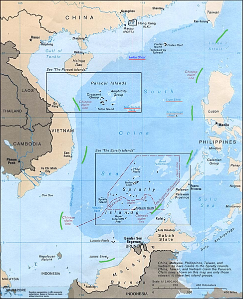
The South China Sea, known as the West Philippine Sea in the Philippines, has been the source of the long standing tension in the region.
It is a semi-enclosed sea in Southeast Asia that covers approximately 2.74 million square kilometers and surrounded by six states and Taiwan. It contains hundreds of small islands, islets and rocks, most of which are uninhabited, with the Paracel and Spratly chains containing the biggest island.
To the north are the southern coast of mainland China and Hainan Island, to the northeast lies Taiwan, to the east and southeast is the Philippines and the southern limits of the sea are bounded by Brunei, Malaysia and Indonesia, and to the west is Vietnam.
The sea is the main maritime link between the Pacific and Indian oceans, giving it enormous trade and military value. Its shipping lanes connect East Asia with Europe and the Middle East. It is believed that unexploited oil and gas deposits lie under the seabed.
Despite the signing of the UNCLOS agreement…
The United Nations Convention on the Law of the Sea (UNCLOS), which came into force on November 16, 1994 and ratified by 164 states is considered as the “Constitution for the Oceans.” Both China and the Philippines are signatories to the UNCLOS which prescribes the maritime entitlements of coastal states as well as their rights, jurisdiction and obligations over these maritime entitlements. Both China and the Philippines have to fulfill in good faith the obligation to exercise the rights, jurisdiction and freedoms recognized under UNCLOS in a manner which would not constitute an abuse of the right.

Despite China’s adherence to UNCLOS in June 1996, China has asserted a claim to “sovereignty” and “sovereign rights” over a vast maritime area lying within a so-called “nine dash line” that encompasses virtually the entire South China Sea. In the east, the “nine dash line” is less than 50M off the Philippine island of Luzon, in the southeast, it is within 30M from Palawan. In both respects, it cuts through the Philippines’ 200M exclusive economic zone and continental shelf, in violation of the UNCLOS. Within the area encompassed by the “nine dash line,” China has engaged in a conduct that has lawfully interfered with the Philippines’ right of navigation, notwithstanding that some of the area is in the Philippines’ own exclusive economic zone and the rest is high seas.
In 1995, China began building structures on the Mischief Reef, within the Philippines’ exclusive economic zone. Tensions between the two nations started to heat up in March 2011, when Chinese vessels harassed a Philippine-chartered gas exploration vessel at Reed Bank.
In June 2012, China formally created a new administrative unit, under the authority of the Province of Hainan that included all of the maritime features and waters within the “nine dash line.” In November 2012, the provincial government of Hainan Province promulgated a law calling for the inspection, expulsion or detention of vessels “illegally” entering the waters claimed by China within this area. The new law went into effect on January 1, 2013.
On January 22, 2013, the Philippines formally conveyed to China the “Philippine Notification and Statement of Claim” that challenges before the Arbitral Tribunal the validity of China’s nine dash line claim to almost the entire South China Sea including the West Philippine Sea and to desist from unlawful activities that violate the sovereign rights and jurisdiction of the Philippines under the 1982 UN Convention on the Law of the Sea (UNCLOS).
The Permanent Court of Arbitration in The Hague, Netherlands said in a statement released on August 27, 2013:
“The Arbitral Tribunal formally adopts the Rules of Procedure and fixes March 30 (next year) as the date on which the Philippines should submit its Memorial.”
Recent Developments
Latest military reports showed that there were 75 concrete blocks allegedly put up by the Chinese. Panatag Shoal, known to China as Huangyan Island, was a site of maritime standoff between China and the Philippines that lasted for two months last year.
The Philippines and the United States launched war games last September 18, 2013 at a naval base facing turbulent waters claimed by China, as the allies sought to highlight their expanding military ties. About 2,300 marines from both sides joined in this annual exercise ahead of US President Barack Obama’s planned first visit to the Philippines in October. The Philippines, which has been seeking US military support to counter what it perceives as a growing Chinese threat to its South China Sea territory, welcomed the exercises as another important plank in building its defense capabilities.
On September 17, 2013, the Department of Foreign Affairs (DFA) through its Spokesman Raul Hernandez said that it was shifting its focus to the establishment of a code of conduct in the disputed West Philippine Sea also known as South China Sea and the arbitration case with China before the international Permanent Court of Arbitration. China has repeatedly refused to participate in the arbitration insisting on bilateral talks.
The Philippines does not seek in this arbitration a determination of which Party enjoys sovereignty over the islands claimed by both of them nor does it request a delimitation of any maritime boundaries.
President Benigno Aquino III, said that “We are not doing this because we want to be an aggressor, we are not doing this because we want escalation. This is about keeping peace. This is about protecting ourselves—something we have long thought impossible.”
—
Krista Gem J. Mercado is currently Chief of Staff at the Philippine House of Representatives, and the newest contributing writer at Wika Magazine.


